Tropical Depression Caloy weakens into LPA
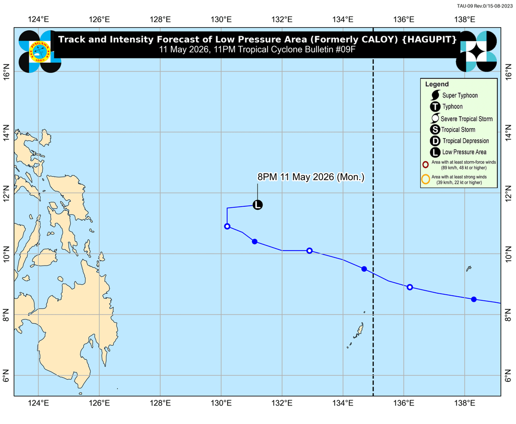
MANILA, Philippines – Caloy (Hagupit) weakened from a tropical depression into a low pressure area (LPA) at 8 pm on Monday, May 11.
The LPA that used to be Caloy was last spotted 600 kilometers east of Guiuan, Eastern Samar, or 630 kilometers east of Borongan City, Eastern Samar, as of 10 pm on Monday.
In its 11 pm bulletin, the Philippine Atmospheric, Geophysical, and Astronomical Services Administration (PAGASA) said the LPA or remnant low is “less likely to bring heavy rainfall” to the country.
It is projected to move generally north or northeast over the Philippine Sea, or away from the country.
“There is a likelihood that it may dissipate within the next five days,” added PAGASA.
But in the next 24 hours, up to moderate seas are possible in the seaboards of Batanes, Cagayan, Isabela, Aurora, and Surigao del Sur; northern seaboards of Camarines Norte and Camarines Sur; northern and eastern seaboards of Quezon including Polillo Islands, Catanduanes, and Northern Samar; and eastern seaboards of Albay, Sorsogon, Eastern Samar, Dinagat Islands, and Siargao-Bucas Grande Islands.
Waves in those seaboards could be up to 2 meters high. The weather bureau advised small vessels to take precautionary measures, or to avoid sailing altogether.
Caloy did not directly affect any part of the Philippines, although its trough or extension has brought scattered rain and thunderstorms to a few provinces on the eastern side of the Visayas and Mindanao.
Caloy entered the Philippine Area of Responsibility (PAR) as a tropical storm last Saturday, May 9, and stayed far from landmass. It was the Philippines’ third tropical cyclone for 2026, and the first for May.
Meanwhile, PAGASA is still monitoring an LPA outside PAR. It was located 1,715 kilometers east of northeastern Mindanao as of 8 pm on Monday.
The LPA remains unlikely to develop into a tropical cyclone within 24 hours. – Rappler.com


You May Also Like

Moomoo US Receives Regulatory Green Light to Launch Prediction Market
Trump biographer: Epstein joked about his legal troubles while orchestrating defense