The story of water (Part 1)
By Patricia B. Mirasol
I. Over 14 million people call Metro Manila home. On weekdays, this number can swell up
to 18 million as workers from neighboring provinces troop to the capital to report for
work.
Millions of people gathering in one place at any given day stretches already strained water
resources, particularly as the government sounded the alarm over El Niño and the
challenges on how to mitigate its effects.
Water is a precious resource, and concerns about a scarcity of supply have been hogging
headlines. But how much do we know of the liquid gold we often take for granted? How
much work goes into supplying taps with a running flow?
Keeping the capital humming is a delicate dance that entails ensuring there are enough
key resources – including water – for all.
II. The flow of potable water
Water that then courses past the Novaliches portal undergoes treatment at the
concessionaires, after which they pass through an underground network of pipes and into
individual households.
III. Agencies involved
Providing water for Metro Manila is the responsibility of the following agencies and
entities: the National Water Resources Board (NWRB), the Metropolitan Waterworks &
Sewerage System (MWSS), and the concessionaires Maynilad Water Services Inc.
(MWSI) and Manila Water Company, Inc. (MWCI).
The reason behind this water management setup traces back to the 1990s, when Metro
Manila faced a water crisis. The Global Atlas of Environmental Justice reports that onethird of all households in the capital had no access to piped water. MWSS, meanwhile,
had a debt of US $880 million and 60% of non-revenue water – which is water lost due to
leaks, theft, or poor metering.
The infrastructure was also inefficient and old.
It was in this backdrop that then-President Fidel V. Ramos privatized water services in
1997 through the Water Crisis Act (Republic Act No. 8041).
Republic Act No. 8041 was aimed at transferring the financial burden of the MWSS to the
private sector to improve service standards, increase operational efficiency, and minimize
tariff impact.
The responsibility to operate and improve the waterworks system was hence passed on to
two private consortia: MWSI for the West Zone, and MWCI for the East Zone.
The east zone served by Manila Water Co. covers parts of the cities of Quezon and Makati,
the southeastern parts of Manila, Taguig, Marikina, Pasig, San Juan, Mandaluyong, the
municipality of Pateros, and Rizal province.
The west zone served by Maynilad Water Services includes parts of Manila and Quezon
City, west of South Superhighway in Makati, Caloocan, Pasay, Parañaque, Las Piñas,
Muntinlupa, Valenzuela, Navotas and Malabon, as well as the municipalities of Bacoor,
Imus, Kawit, Noveleta and Rosario in Cavite province.
The MWSS, through its Regulatory Office’s Technical Regulation area, is tasked to ensure
that both Maynilad and Manila Water meet their service obligations, which encompasses
disaster resilience and infrastructure reliability.
This includes resilience against The Big One.
The Big One refers to a major earthquake that could strike along the West Valley Fault,
located directly underneath the capital. According to the World Bank in a March 2023
post, this probable maximum scenario could result in an estimated 48,000 fatalities and
$48 billion (or about P2.83 trillion, based on the November 19, 2025 exchange rate of
P58.91 for every $1) in economic losses.
The Philippine government and the Japan International Cooperation Agency are in talks
to revisit in 2026 the latter’s 2004 study on the impact of The Big One.
 Photo credit | ERVIN MALICDEM, 2015
Water service reliability includes ensuring water remains available even during times of
calamity, said Jeric T. Sevilla, Jr., spokesperson for Manila Water, adding there are
projects earmarked for this probability.
“Manila Water’s projects include the construction of emergency reservoirs,” he said.
“These are placed on basketball courts and schools, so there will be available water – at
least for drinking – in times of calamities.”
“We have already begun reinforcing our plants and facilities to be able to withstand a
magnitude 7.2 earthquake,” he added.
In a message to BusinessWorld, Maynilad said they’ve likewise retrofitted their pipes for
such purposes.
IV. Angat
Angat is at the heart of this story, as over 90% of the water’s capital comes from it – over
60 years since it was commissioned in 1967.
Angat Dam’s strategic location is part of why it became Metro Manila’s primary water
source. It harnesses the flow of the Angat River, which originates from the Sierra Madre
mountains.
The forest reserve surrounding the dam likewise provides a large catchment area, making
it ideal for collecting and storing water.
Situated largely in the Bulacan municipalities of Dona Remedios Trinidad, Norzaragay
and San Jose Del Monte, the Angat Watershed Reservation lies on the southernmost tip
of the Sierra Madre Mountain Range. Its Northeastern boundaries, meanwhile, stretch
into the municipalities of General Tinio, the province of Nueva Ecija and Infanta, and the
province of Quezon.
The dam was also chosen in the 1960s over other proposed projects – like the Marikina
Multi-Purpose Project – due to geological concerns in Marikina. Then-Bulacan
congressman Rogaciano M. Mercado supported the Angat project, which helped push its
development forward.
An increase in the demand for potable water in the 1990s, meanwhile, led to the
enactment of the Umiray-Angat Transbasin Project, which further added 780 million
liters per day to the reservoir by diverting water from the Umiray River in Quezon to
Angat Dam.
Angat Dam’s socio-economic value is as follows:
- Main source of water for Angat Hydro-electric power plant
- Main source of water for the irrigation of about 31,485 hectares of riceland in 16
municipalities of Bulacan and 4 municipalities of Pampanga - Provides 4000 million liters per day to Metro Manila
- An ideal place for nature tripping, mountain climbing, boating and bird watching,
and biodiversity studies/research - Home to more than 800 indigenous families known as Dumagats found residing
in fourteen resettlement areas.
The National Power Corporation (NPC) has a master plan for the protection of the Angat
watershed, said Emmanuel A. Umali, NPC’s department manager for the Watershed
Management Department.
“We identified three major zones in the watershed,” he said in an interview. “These are
mainly the strict protection areas where we employ forest protection activities and
enforcement of forest laws, rules and regulations” through partners such as volunteers
and the military, he added.
The Angat watershed, Mr. Umali said, “is the only remaining forested area in the Metro
Manila, and it serves as the lungs of the metropolis…because the area is still forested.”
Angat Dam structural integrity is sound, Wilfredo S. Senadrin, NPC’s manager for the
Dams, Reservoirs, and Waterways Division, also said.
“As long na ginagawa mo yung proper maintenance, hindi mawawala yun (As long as
you conduct the proper maintenance, that’s not going to change),” he said in a separate
interview.
The dam’s retrofitting was completed in 2018 by flattening the downstream slope to
further improve its slope stability.
He told BusinessWorld that its being an embankment type of dam contributes to Angat’s
strength:
“Kung matatandaan niyo nung 1990 …nung nagkaroon tayo ng earthquake sa
Luzon…Ang epicenter nun nandiyan lang sa Nueva Ecija, e gaano kalapit lang sa Angat,
pero ang Angat walang naging problema (If you remember, there was an earthquake in
Luzon in 1990. The epicenter was in Nueva Ecija, which is near Angat, but Angat didn’t
encounter problems then).”
Notwithstanding the dam’s sturdy structure, El Niño and changing rainfall patterns due
to climate change still pose a threat to Metro Manila’s water supply.
Recycling water is one way to combat this global issue, according to Maynilad.
“The Angat-Ipo system is affected because of climate change, [which includes] El Niño
and La Niña,” Ronaldo C. Padua, Maynilad’s spokesperson and vice president and head
of water supply operations, said.
Maynilad, he said in an interview with BusinessWorld, has started reducing its reliance
on the Angat-Ipo system by tapping Laguna Lake.
It has two water treatment plants (WTPs) in Muntinlupa, each with a capacity of 150
million liters per day (MLD).
“In Laguna Lake, [on the other hand,] we are being affected mainly by the water quality,”
he also said. “It’s actually ten times more expensive [to treat water from Laguna Lake]
than it is to treat water from here in the treatment plants in La Mesa.”
In December 2023, Maynilad inaugurated a third WTP in Laguna Lake, for which they
get about 150 MLD to serve Manila and parts of Cavite.
It also started operations at its P1.6-billion Cupang Water Reclamation Facility (WRF) in
Muntinlupa, which can treat 46 million liters of wastewater daily. The facility is designed
to serve approximately 33,000 customers in Sucat, Buli, Cupang, and Bayanan,
Muntinlupa.
“Maynilad is doing all its efforts for us to be able to adapt to this ever-changing condition
of our water sources,” Mr. Padua added. “We are ensuring that we are partnering with the
different government agencies and doing some education campaigns to our customers.”
V. Laguna Lake
Laguna Lake is the largest freshwater lake in the Philippines and the third largest inland
body of water in South-East Asia, after Toule Sap of Cambodia and Lake Toba of Sumatra.
The W-shaped body of water has two peninsulas in the north. The middle lake lobe
between the two fills the large volcanic Laguna Caldera, formed by two volcanic eruptions
sometimes between 1 million and 27,000 years ago. There is a total of nine islands on the
lake of which the largest is Talim Island, which is part of the division between the West
and Center Bay.
 LLDA
LLDA
Laguna de Bay – as the lake is also known – has an area of 90,000 hectares, an average
depth of 2.5 meters, and an estimated 3.2 trillion liters of water.
It provides the rest of the capital’s needs at present, with the western side utilized by
Maynilad and the eastern side by Manila Water.
Maynilad, for its part, has two WTPs in Putatan, Muntinlupa City that serve a 1.6-million
population
Manila Water, on the other hand, is completing its East Bay Water Supply System (Phases
1 and 2), which is expected to serve approximately 2.08 million customers.
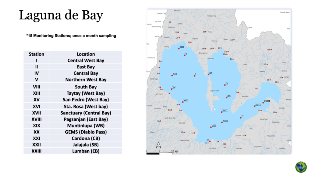
The Laguna Lake Development Authority (LLDA), is responsible for monitoring and
maintaining water quality of the lake and its 21 major tributary rivers.
It has been monitoring the lake and the rivers since the 1970s and now has 16 lake
stations and 36 river stations in the 24 sub basins of the region as of 2024.
An attached agency of the Department of Environment and Natural Resources (DENR),
the LLDA also issues permits for both concessionaires for the abstraction of water from
the lake.


You May Also Like

Bitcoin Price Dips as US-Europe Alliance Reaches ‘Breaking Point’ Over Iran War: Report

Japan’s Bond Shock Could Trigger the Next Global Crypto Sell-Off