Typhoon Francisco rapidly intensifies east of Cagayan
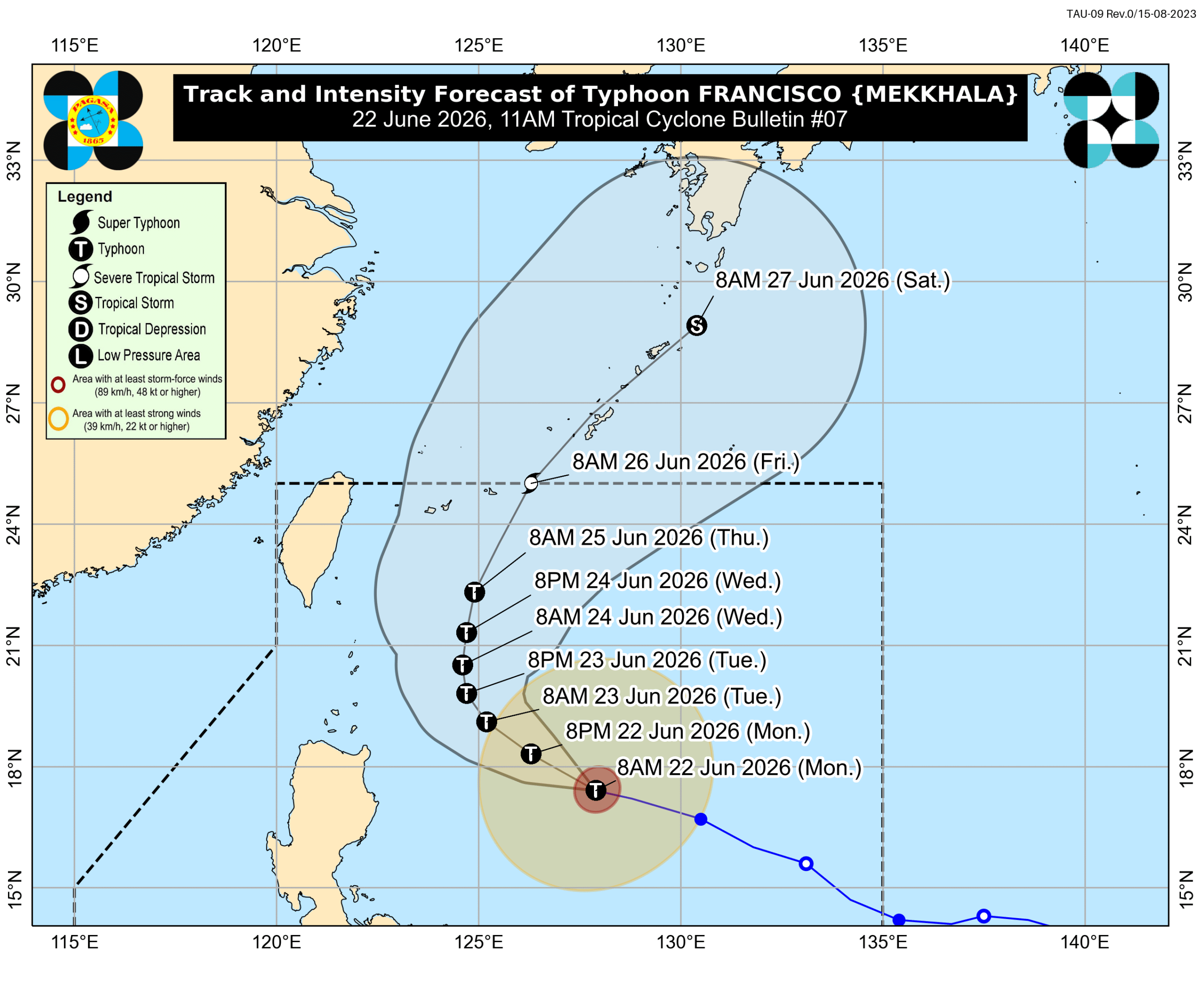
MANILA, Philippines – Typhoon Francisco (Mekkhala) rapidly intensified over the Philippine Sea on Monday morning, June 22, with its maximum sustained winds increasing from 140 kilometers per hour to 155 km/h.
The typhoon’s gustiness is now up to 190 km/h from the previous 170 km/h, said the Philippine Atmospheric, Geophysical, and Astronomical Services Administration (PAGASA) in a bulletin issued at 11 am on Monday.
Given this latest development, PAGASA is not ruling out the possibility of Francisco reaching super typhoon category. Under the weather bureau’s classification system, a super typhoon has maximum sustained winds of at least 185 km/h.
Francisco was last spotted 620 kilometers east of Tuguegarao City, Cagayan, as of 10 am on Monday. It slowed down, moving west northwest at 15 km/h from 30 km/h.
The typhoon is not expected to make landfall in the Philippines, as it may eventually recurve toward Japan’s Ryukyu Islands. But a “slight westward shift” in its track is still possible, according to PAGASA.
While Francisco won’t make landfall, Batanes and Cagayan could have moderate to heavy rain (50-100 millimeters) on Tuesday, June 23, and Wednesday, June 24. Floods and landslides are possible in high-risk areas.
On Monday, the southwest monsoon or habagat is bringing scattered rain and thunderstorms to the Visayas, Mindanao, and Palawan. The rest of Luzon could just have localized thunderstorms.
Meanwhile, the following areas remain under Signal No. 1, which means they will see strong winds from the typhoon:
- Batanes
- northeastern part of Cagayan (Gonzaga, Santa Ana) including the eastern part of Babuyan Islands (Babuyan Island, Didicas Island, Camiguin Island)
The southwest monsoon and Francisco’s periphery or outer bands are also bringing strong to gale-force gusts to these areas:
Monday, June 22
- La Union, Pangasinan, Calabarzon, Marinduque, Romblon, Masbate, most of Visayas, Zamboanga Peninsula, Misamis Occidental, Lanao del Norte, Camiguin, Surigao del Norte, Dinagat Islands, Davao Occidental, Davao Oriental
Tuesday, June 23
- most of Luzon, Visayas, Zamboanga Peninsula, Northern Mindanao, Surigao del Norte, Dinagat Islands, Davao Occidental, Davao Oriental
Wednesday, June 24
- most of Luzon, Visayas, Misamis Occidental, Lanao del Norte, Camiguin, Dinagat Islands, Davao Occidental, Davao Oriental
On Monday, conditions in certain seaboards remain risky, especially for small vessels.
Up to rough seas (small vessels should not venture out to sea)
- Eastern seaboards of Babuyan Islands and mainland Cagayan – waves up to 3.5 meters high
- Eastern seaboards of Batanes, Isabela, and northern Aurora – waves up to 3 meters high
Up to moderate seas (small vessels should take precautionary measures or avoid sailing, if possible)
- Remaining seaboards of Batanes, Babuyan Islands, mainland Cagayan, and Aurora; northern and eastern seaboards of Polillo Islands and Catanduanes; northern seaboards of Camarines Norte and Camarines Sur; eastern seaboard of Davao Oriental – waves up to 2.5 meters high
- Seaboard of northern Quezon; northern seaboard of Ilocos Norte; northern and eastern seaboards of Northern Samar; eastern seaboards of Albay, Sorsogon, Eastern Samar, Dinagat Islands, and Surigao del Sur; eastern and southern seaboards of Davao Occidental; southern seaboard of Davao Oriental – waves up to 2 meters high
Francisco is the Philippines’ sixth tropical cyclone for 2026, and the second for June. It could leave the Philippine Area of Responsibility (PAR) on Friday, June 26.
Aside from Francisco, PAGASA continues to monitor a low pressure area (LPA) outside PAR, located 2,745 kilometers east of southeastern Luzon as of 10 am on Monday.
This LPA now has a medium chance of developing into a tropical depression within 24 hours. Further updates will be given in the coming days.
PAGASA had announced the onset of the southwest monsoon last May 30, and the start of the rainy season on June 4. – Rappler.com


You May Also Like

The latest smelly episode in Trump’s embarrassing Reflecting Pool saga

Mexican Peso Slides as Dollar Strengthens on Fed Repricing Ahead of Banxico Decision

If Japan’s Interest Rates Hit 6%, 100% of Tax Revenue Goes to Debt Interest. America Could Be Next.


Trending News
More24/7 Live News
MoreQuick Reads
More