Typhoon Francisco strengthens further while moving east of Central Luzon
MANILA, Philippines – Typhoon Francisco (Mekkhala) intensified further on Sunday evening, June 21, with its maximum sustained winds increasing from 120 kilometers per hour to 130 km/h.
The typhoon’s gustiness is now up to 160 km/h from 150 km/h, according to the 11 pm bulletin of the Philippine Atmospheric, Geophysical, and Astronomical Services Administration (PAGASA).
Francisco was last spotted 875 kilometers east of Central Luzon at 10 pm on Sunday, still moving west northwest at 25 km/h.
The typhoon remains unlikely to make landfall, but PAGASA is not ruling out “a closer approach to extreme Northern Luzon” in case its track shifts further westward.
The weather bureau’s latest forecast also shows that both Francisco and the southwest monsoon or habagat, which will be enhanced by the typhoon, may trigger heavy rain starting Monday, June 22, or Tuesday, June 23. Parts of Luzon and the Visayas could be affected, with the exact areas to be specified in succeeding advisories.
For now, the trough or extension of the typhoon is bringing scattered rain and thunderstorms to Bicol, while the southwest monsoon is causing similar conditions in Mindanao, the Visayas, and Palawan. In the rest of Luzon, there could be localized thunderstorms.
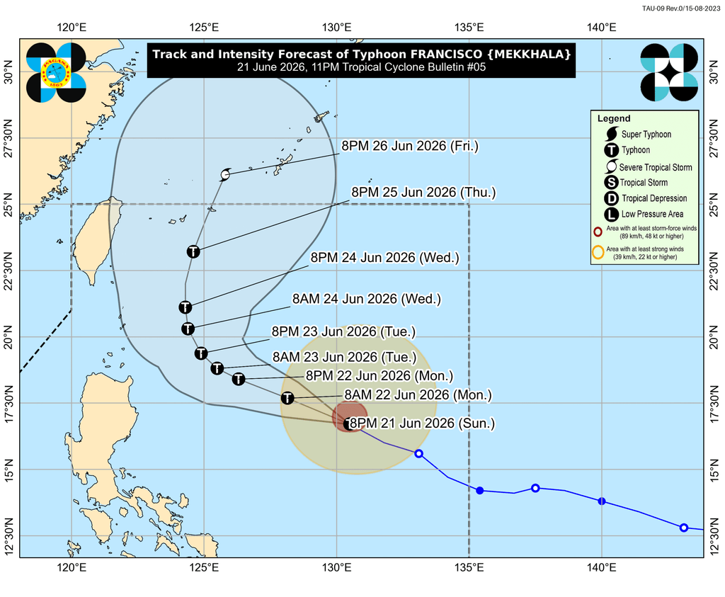
In anticipation of strong winds from Francisco, Signal No. 1 might be raised for portions of Cagayan, Babuyan Islands, and Batanes by Monday morning.
The southwest monsoon is also bringing strong to gale-force gusts to the following areas:
Sunday, June 21
- Siquijor, Camiguin, southern part of Bohol, Southern Leyte, Davao Oriental, Davao Occidental, Sarangani
Monday, June 22
- La Union, Pangasinan, Calabarzon, Romblon, Masbate, most of Visayas, Basilan, Sulu, Zamboanga Peninsula, Misamis Occidental, Lanao del Norte, Camiguin, Surigao del Norte, Dinagat Islands, eastern part of Davao Occidental, eastern and southern parts of Davao Oriental
Tuesday, June 23
- most of Luzon, Visayas, Zamboanga Peninsula, Northern Mindanao, Surigao del Norte, Dinagat Islands, Davao Occidental, Davao Oriental
Meanwhile, PAGASA is now warning of rough seas, particularly on the eastern side of Northern Luzon. For the next 24 hours, conditions will be risky in the following seaboards:
Up to rough seas (small vessels should not venture out to sea)
- Eastern seaboards of Cagayan and Isabela – waves up to 3 meters high
Up to moderate seas (small vessels should take precautionary measures or avoid sailing, if possible)
- Remaining seaboards of Cagayan; seaboards of Batanes and Aurora; northern and eastern seaboards of Polillo Islands; northern seaboards of Camarines Norte and Camarines Sur; eastern seaboard of Davao Oriental – waves up to 2.5 meters high
- Northeastern seaboard of mainland Quezon; northern and eastern seaboards of Catanduanes and Northern Samar; eastern seaboards of Albay, Sorsogon, Eastern Samar, Dinagat Islands, Surigao del Sur; southern seaboard of Davao Oriental – waves up to 2 meters high
Francisco is the Philippines’ sixth tropical cyclone for 2026, and the second for June. It could leave the Philippine Area of Responsibility (PAR) on Friday, June 26.
Aside from Francisco, PAGASA continues to monitor a low pressure area (LPA) outside PAR, located 2,985 kilometers east of southeastern Luzon as of 8 pm on Sunday.
This LPA still has a low chance of developing into a tropical depression within 24 hours. Further updates will be given in the coming days.
PAGASA had announced the onset of the southwest monsoon last May 30, and the start of the rainy season on June 4. – Rappler.com


You May Also Like

Arbitrum Announces Ten Innovative Teams — And Why It’s Not Just Hype

Cathie Wood’s ARK Invest Buys $13.7M in Circle Shares While Selling Robinhood Stock

The changing face of elder care in Malaysia — Sayed Mohammad Reza Yamani Sayed Umar