Must Read
MAYON VOLCANO. A dome-collapse pyroclastic density current at Mayon Volcano in Albay generates ash clouds on January 8, 2026.MAYON VOLCANO. A dome-collapse pyroclastic density current at Mayon Volcano in Albay generates ash clouds on January 8, 2026.
More areas under Signal No. 1 due to Tropical Storm Ada
For feedback or concerns regarding this content, please contact us at crypto.news@mexc.com
MANILA, Philippines – More areas were placed under Signal No. 1 due to strong winds from Tropical Storm Ada (Nokaen) on Friday afternoon, January 16.
As of 4 pm on Friday, Ada was located 255 kilometers east northeast of Borongan City, Eastern Samar, or 335 kilometers east of Catarman, Northern Samar. The tropical storm slightly accelerated, moving northwest at 20 kilometers per hour from 15 km/h.
It continues to have maximum sustained winds of 65 km/h and gustiness of up to 80 km/h.
The Philippine Atmospheric, Geophysical, and Astronomical Services Administration (PAGASA) said in its 5 pm bulletin on Friday that Ada is likely to remain a tropical storm while moving over the sea east of the Visayas and Southern Luzon.
It is still projected to pass close to Eastern Samar and Northern Samar on Saturday, January 17, and Catanduanes from Saturday evening to Sunday, January 18. Landfall in Eastern Visayas and/or Bicol remains a possibility, however, in case Ada’s track shifts further westward.
Afterwards, Ada could weaken into a tropical depression by Tuesday, January 20, and into a remnant low by Wednesday, January 21, due to the surge of the northeast monsoon or amihan.

Below are the areas under Signal No. 1 as of 5 pm on Friday.
- southern part of Quezon (San Narciso, Mulanay, San Francisco, San Andres, Buenavista, Catanauan, Lopez, Calauag, Guinayangan, Tagkawayan)
- Camarines Norte
- Camarines Sur
- Catanduanes
- Albay
- Sorsogon
- Masbate
- Northern Samar
- Samar
- Eastern Samar
- Biliran
- Leyte
- Southern Leyte
- northern part of Cebu (Medellin, Daanbantayan, San Remigio, Bogo City, Tabogon) including Camotes Islands and Bantayan Islands
- Dinagat Islands
- Siargao-Bucas Grande Islands
The highest possible tropical cyclone wind signal due to Ada is Signal No. 2.
The northeast monsoon and the periphery of the tropical storm may also bring strong to gale-force gusts to these areas:
Friday, January 16
- Batanes, Babuyan Islands, Ilocos Norte, Aurora, Quezon, Lubang Islands, Oriental Mindoro, Romblon, Marinduque, Cuyo Islands, Bicol, Visayas, Agusan del Norte, Surigao del Norte, Surigao del Sur, Davao Oriental, Davao Occidental, Sarangani
Saturday, January 17
- Batanes, Babuyan Islands, northern and eastern mainland Cagayan, eastern Isabela, Ilocos Norte, Aurora, Quezon, Oriental Mindoro, Romblon, Marinduque, Cuyo Islands, Bicol, Visayas, Dinagat Islands, Surigao del Norte
Sunday, January 18
- Batanes, Cagayan, Isabela, Quirino, Abra, Ilocos Norte, Ilocos Sur, Quezon, Marinduque, Romblon, Bicol, Eastern Visayas
Ada is no longer expected to trigger significant rain in portions of Mindanao in the next 48 hours, but Eastern Visayas and Bicol will still be rainy. Floods and landslides remain likely.
Friday afternoon, January 16, to Saturday afternoon, January 17
- Heavy to intense rain (100-200 millimeters): Catanduanes, Albay, Sorsogon, Northern Samar, Eastern Samar
- Moderate to heavy rain (50-100 mm): Camarines Sur, Masbate, Samar, Biliran, Leyte, Southern Leyte
Saturday afternoon, January 17, to Sunday afternoon, January 18
- Moderate to heavy rain (50-100 mm): Catanduanes, Camarines Norte, Camarines Sur, Albay
In addition, PAGASA warned the public that there is a minimal to moderate risk of storm surges with peak heights of up to 2 meters in Camarines Sur, Catanduanes, Albay, Sorsogon, Northern Samar, Eastern Samar, and Samar within 48 hours. Check the specific cities and municipalities here.
Conditions in certain seaboards, especially in Bicol, are also worsening in the next 24 hours.
Up to very rough seas (travel is risky for all vessels)
- Eastern seaboards of Catanduanes, Albay, and Sorsogon; northern and eastern seaboards of Northern Samar – waves up to 5 meters high
- Seaboard of Camarines Norte; northern seaboards of Camarines Sur and Catanduanes – waves up to 4.5 meters high
Up to rough seas (small vessels should not venture out to sea)
- Northern and eastern seaboards of Polillo Islands; eastern seaboard of Eastern Samar – waves up to 4 meters high
- Seaboards of Isabela, Aurora, and northern mainland Quezon – waves up to 3.5 meters high
- Seaboard of Babuyan Islands; eastern seaboards of mainland Cagayan, Camarines Sur, and Dinagat Islands; northern and eastern seaboards of Siargao-Bucas Grande Islands; remaining seaboards of Catanduanes – waves up to 3 meters high
Up to moderate seas (small vessels should take precautionary measures or avoid sailing, if possible)
- Seaboards of Batanes, Ilocos Norte, Surigao del Sur, and Davao Occidental; northern seaboard of mainland Cagayan; eastern seaboards of Surigao del Sur and Davao Oriental – waves up to 2.5 meters high
- Seaboards of Marinduque, Romblon, Cuyo Islands, Cagayancillo Islands, Aklan, Capiz, Antique, northern mainland Cebu, Bantayan Islands, Camotes Islands, Agusan del Norte, and Southern Leyte; northern and western seaboards of Surigao del Norte and Dinagat Islands; remaining seaboards of Quezon, Bicol, and Eastern Visayas – waves up to 2 meters high
Ada is the Philippines’ first tropical cyclone for 2026.
PAGASA expects two to eight tropical cyclones to form within or enter the Philippine Area of Responsibility in the first half of 2026. These are the estimates per month:
- January – 0 or 1
- February – 0 or 1
- March – 0 or 1
- April – 0 or 1
- May – 1 or 2
- June – 1 or 2
– Rappler.com
Market Opportunity
Storm Trade Price(STORM)
$0.004024
$0.004024$0.004024
USD
Storm Trade (STORM) Live Price Chart


Disclaimer: The articles reposted on this site are sourced from public platforms and are provided for informational purposes only. They do not necessarily reflect the views of MEXC. All rights remain with the original authors. If you believe any content infringes on third-party rights, please contact crypto.news@mexc.com for removal. MEXC makes no guarantees regarding the accuracy, completeness, or timeliness of the content and is not responsible for any actions taken based on the information provided. The content does not constitute financial, legal, or other professional advice, nor should it be considered a recommendation or endorsement by MEXC.
You May Also Like

Palantir (PLTR) Stock Plunges 20% in 2026 — Analysts Signal Strong Buy Opportunity
The post Palantir (PLTR) Stock Plunges 20% in 2026 — Analysts Signal Strong Buy Opportunity appeared on BitcoinEthereumNews.com. Quick Overview Palantir shares
Share
BitcoinEthereumNews2026/04/26 01:25

The Chemistry of UV Resistance: How Titanium Dioxide Protects Against the California Sun
Homeowners considering synthetic boundary systems frequently voice a singular, pervasive concern: “Will the material turn yellow and brittle after a few years in
Share
Techbullion2026/04/02 18:06
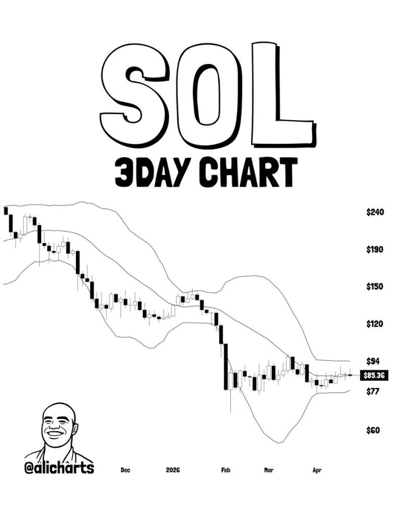
Solana (SOL) Price Looks Trapped, But This Bullish Signal Just Flashed – Here’s the Outlook
The SOL price is trading near $85, stuck in a tight range between $77 and $94. That is a 71% discount from its all time high. Ali Martinez notes that the Bollinger
Share
Captainaltcoin2026/04/26 01:00